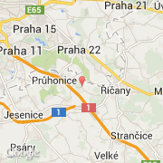
Ville de Nupaky (Hlavní město Praha)

republique-tcheque

Informations

Chiffres

Code pays :
CZ
Code postal :
251-01
Latitude :
49.99536
Longitude :
14.60243
Zone horaire :
Europe/Prague
Fuseau horaire :
UTC+1
Heure d'été :
Y

La ville de Nupaky appartient à la région Hlavní město Praha, au district Praha-východ et à la commune Říčany u Prahy.

La ville de Nupaky compte 775 habitants (recensement de 2011). L'altitude moyenne est de 315 m.
Le nom anglais de la ville est Nupaky.

Villes voisines

Les transports de Nupaky

Aéroport international
Ruzyne ~27 km
Autres transports
Kbely ~15 km
Praha hlavni nadrazi ~15 km
Florenc Central Bus Station ~16 km
Vodochody ~29 km
Sazena ~39 km
Booking.com

Rejoignez-nous !

Vous aimez ? Partagez !