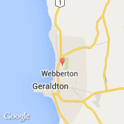
Ville de Spalding (Western Australia)

australie

Informations

Chiffres

Code pays :
AU
Code postal :
6530
Latitude :
-28.73857
Longitude :
114.63293
Zone horaire :
Australia/Perth
Fuseau horaire :
UTC+8
Heure d'été :
Y

La ville de Spalding appartient à l'état Western Australia et à la région Kalgoorlie.

La ville de Spalding s'étend sur 5 km² et compte 2 484 habitants pour une densité de 496,80 habitants par km².
Le nom anglais de la ville est Spalding.

Villes voisines

  • Bluff Point ~1 km
  • Webberton ~2 km
  • Strathalbyn ~2 km
  • Sunset Beach ~2 km
  • Beresford ~3 km
  • Wonthella ~3 km
  • Waggrakine ~3 km
  • Moresby ~3 km
  • Glenfield ~4 km
Booking.com

Rejoignez-nous !

Vous aimez ? Partagez !